Tracking emergencies - who gets the data?
 Chemical sensors are capable of detecting and analyzing gases in order to alert us to airborn pollutants from industrial processes, smog, natural events such as volcanic eruption and even terrorist activities (hopefully before they occur). These devices can be arranged wherever we require an awareness of what the air is carrying. US embassies use air quality units to release air quality measurements, sometimes in real time - or not at all.
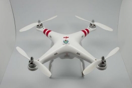
When there is a major event, awareness of risk conditions for first-responder units is key. This week, Popular Science covered a Connecticut fire department using a drone to identify risk conditions for fire fighters at a quarry. While there isn't much new in using remote controlled devices to minimize the risk to human lives - bomb squads and SWAT teams have used robots for some time to get a look at situations before sending in humans - the drone provided a very different look from the air.
In this case, the fire department used the drone to make certain the fire wasn't dangerously close to a structure storing explosives. Combining one of these units with chemical sensors would allow fire departments or other first responders to swarm an area and feed a great detail of data to be analyzed even before a full complement of support personnel could arrive.
As drones become more intelligent and aware, swarms of drones could be launched at an event. A combination of cameras viewing the area via different wavelengths via visible and invisible light, especially infrared, might be able to identify people and animals, buildings, vehicles, hot spots and even track movement over time. Sensors could read the air for a range of chemicals, identifying probably origins for various combinations. This could allow one type of responder to alert another before any human agent has laid eyes on a danger requiring a different specialty.
The risk, as we see with the many governments hovering up as much data as they can get, is how detailed this data can will be and who is allowed access. Google's satellite mapping was used to locate Greek tax evaders who had installed swimming pools and other valuable house additions without reporting them. Drones can be used to look at crop fields and identify regions where more - or less - irrigation is required or areas where a chemical to manage weeds or pests can be placed - and by limiting the coverage, saving farmers money per acre.
These are great example of identifying lawbreakers and saving money and out water systems by limiting the use of toxins as needed. As drones become less expensive and more capable, they will also adopt capabilities such as gunshot awareness and speed awareness. A hive of drones over a city would be useful for identifying dangerous conflict, the heat and chemicals from fires, speeding cars and other threats. They would also be able to see how many people are at an event, what chemicals a company might be testing to create a new product, and how many deliveries a business is receiving. As the details grows, our privacy shrinks and data can be used in ways to charge us for currently free options.
Would you be comfortable with swarms of drones tracking your movement and other life details if it meant the ability to more easily identify hazards such as violent offenders and fires?
 Interested in the social impact of our future advancements, Daryl developed and built Regarding Tomorrow as a platform to share and discuss our collective hopes and fears of the future. Daryl's background is in education, including graduate studies in special needs and a masters in instructional technology from UVA's Curry School of Education. He has worked as a high school teacher and has over 10 years of university experience in the US and Canada.